
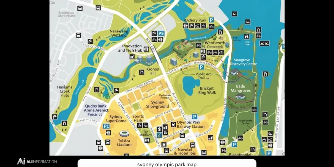
A Sydney Olympic Park map is one of the most useful tools for anyone visiting one of Australia’s largest sporting, entertainment and recreation precincts. Covering more than 640 hectares, Sydney Olympic Park is not simply a collection of stadiums; it is a complete urban destination featuring world-class venues, parks, restaurants, transport connections, cycling paths and family attractions.
Located in Sydney’s west, the precinct has transformed dramatically since it hosted the 2000 Sydney Olympic and Paralympic Games. What was once an industrial area became an internationally recognised destination that now welcomes millions of visitors each year for concerts, sporting events, festivals, community activities and outdoor recreation.
Because the precinct is spread across a large area, understanding the Sydney Olympic Park map can make a major difference when planning a visit. Whether attending a concert at Qudos Bank Arena, watching a football match at Accor Stadium, exploring Bicentennial Park or visiting with family, knowing the layout helps visitors save time and avoid confusion.
Understanding the Sydney Olympic Park Layout
Sydney Olympic Park is designed as a connected precinct where venues, public spaces and transport links are located within walking distance of each other.
The area is divided into several key zones, including:
- Major sporting venues
- Entertainment facilities
- Parklands and recreation areas
- Commercial and dining areas
- Transport hubs
- Residential developments
A good map of Sydney Olympic Park helps visitors identify the shortest walking routes between locations and understand where facilities such as parking stations, train platforms, bike paths and entrances are located.
Major Venues Shown on the Sydney Olympic Park Map
One of the main reasons people search for the Sydney Olympic Park map is to locate major event venues.
Accor Stadium
Formerly known as Stadium Australia, Accor Stadium is one of the most recognisable landmarks in the precinct.
The stadium hosts:
- Rugby league matches
- Football games
- Major concerts
- International sporting events
It was the centrepiece of the 2000 Olympic Games and remains one of Australia’s largest stadiums.
Visitors attending events should check the map before arrival because different entrances are used depending on seating areas and event arrangements.
Qudos Bank Arena
Qudos Bank Arena is Sydney’s premier indoor entertainment venue.
The arena hosts:
- International music concerts
- Family shows
- Sporting events
- Entertainment productions
During major concerts, thousands of visitors arrive at once, making it especially important to understand nearby transport routes and pedestrian access points.
Sydney Showground
Sydney Showground is a major exhibition and event space within the precinct.
It is known for hosting:
- Royal Easter Show events
- Exhibitions
- Festivals
- Trade shows
- Community events
The location is clearly marked on most Sydney Olympic Park maps because it attracts large crowds throughout the year.
CommBank Stadium
CommBank Stadium is another important venue nearby, mainly used for:
- Football
- Rugby league
- Community sporting events
Its location makes Sydney Olympic Park an important destination for sports fans across Sydney.
Sydney Olympic Park Aquatic Centre
The Aquatic Centre remains one of the precinct’s most popular recreational facilities.
It offers:
- Swimming pools
- Water activities
- Fitness facilities
- Family recreation
The venue is especially popular among families looking for affordable activities outside major event days.
Cathy Freeman Park
Named after Australian Olympic champion Cathy Freeman, this open green space is located near several major venues.
The park provides:
- Event gathering areas
- Open lawns
- Walking spaces
- Family-friendly recreation
It is a useful landmark when navigating the precinct.
Bicentennial Park: The Green Heart of Sydney Olympic Park
A Sydney Olympic Park map usually highlights Bicentennial Park, one of the area’s most valuable natural attractions.
The park provides a peaceful contrast to the large stadiums and entertainment venues.
Visitors can enjoy:
- Walking tracks
- Cycling paths
- Picnic areas
- Wetlands
- Bird watching
- Family activities
It is one of the best places in Sydney Olympic Park for visitors who want outdoor recreation rather than organised events.
Transport Information on the Sydney Olympic Park Map
Transport is one of the most important features shown on a Sydney Olympic Park map.
The precinct is well connected through:
Sydney Olympic Park Train Station
The train station is located near many major venues and provides convenient access during events.
Visitors should remember:
- Large events can create significant crowds
- Trains may operate with increased services
- Leaving early can reduce waiting times
Bus Services
Several bus routes connect Sydney Olympic Park with surrounding suburbs.
Buses are useful for visitors travelling from areas without direct train access.
Driving and Parking
Sydney Olympic Park has multiple parking facilities, but availability can become limited during major events.
A map can help visitors identify:
- Parking stations
- Drop-off zones
- Accessible parking areas
- Walking routes from parking locations
Walking and Cycling Routes
One of the strengths of Sydney Olympic Park is its network of pedestrian and cycling paths.
The precinct includes:
- Dedicated cycleways
- Walking trails
- Park connections
- Scenic routes
Visitors can explore much of the area without needing a vehicle.
Cycling is particularly popular because the precinct connects with wider Sydney cycling networks.
Family Attractions Near Sydney Olympic Park
A Sydney Olympic Park map is also useful for families because the area offers many activities beyond stadium events.
Popular attractions include:
- Playgrounds
- Parks
- Aquatic facilities
- Wildlife experiences
- Outdoor recreation areas
Families can easily spend an entire day exploring the precinct.
Tips for Using the Sydney Olympic Park Map Effectively
First-time visitors can make their experience easier by following a few simple tips.
Check Your Venue Before Arriving
Sydney Olympic Park is large. Always confirm:
- Exact venue location
- Entrance gate
- Event start time
- Transport options
Arrive Early for Major Events
Concerts and sporting events can create heavy crowds.
Arriving early allows time for:
- Parking
- Security checks
- Finding seats
- Buying food and drinks
Wear Comfortable Shoes
Many visitors underestimate the walking distance between venues.
Comfortable footwear is recommended, especially during large events.
Plan Return Transport
After major events, thousands of people leave at the same time.
Checking transport options before arrival can prevent delays.
Future Development of Sydney Olympic Park
Sydney Olympic Park continues to evolve as Sydney’s population grows and demand for entertainment, recreation and residential spaces increases.
Future development is expected to focus on:
- More housing
- Improved transport connections
- New commercial areas
- Expanded community facilities
- Better pedestrian experiences
The precinct is becoming not only an event destination but also a modern urban community.
Conclusion
The Sydney Olympic Park map is more than a simple navigation tool. It provides a complete overview of one of Sydney’s most important destinations, helping visitors understand the relationship between stadiums, parks, transport and attractions.
From world-famous venues like Accor Stadium and Qudos Bank Arena to peaceful locations such as Bicentennial Park, Sydney Olympic Park offers something for sports fans, families, tourists and local residents.
Planning ahead with a map allows visitors to make the most of their experience, avoid unnecessary delays and explore everything this remarkable precinct has to offer.




No Comments